


Precinct 1, Cedar County, Nebraska
About
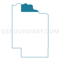
Outline

Summary
| Unique Area Identifier | 612563 |
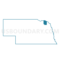
| Name | Precinct 1 |
| County | Cedar County |
| State | Nebraska |
| Area (square miles) | 40.94 |
| Land Area (square miles) | 38.41 |
| Water Area (square miles) | 2.53 |
| % of Land Area | 93.81 |
| % of Water Area | 6.19 |
| Latitude of the Internal Point | 42.82088370 |
| Longtitude of the Internal Point | -97.27833410 |
Maps

Graphs
Select a template below for downloading or customizing gragh for Precinct 1, Cedar County, Nebraska


Neighbors
Neighoring Voting District (by Name) Neighboring Voting District on the Map
- Precinct 2, Cedar County, NE
- Precinct 3, Cedar County, NE
- Precinct 4, Cedar County, NE
- VTD-precinct 28, Yankton County, SD
- VTD-precinct 29 GayvilleTwp, Yankton County, SD
- VTD-precinct W03, Clay County, SD
Top 10 Neighboring County Subdivision (by Population) Neighboring County Subdivision on the Map
- Southeast Yankton UT, Yankton County, SD (940)
- Precinct 2, Cedar County, NE (468)
- Precinct 5, Cedar County, NE (423)
- Precinct 1, Cedar County, NE (374)
- Precinct 4, Cedar County, NE (345)
- Precinct 3, Cedar County, NE (339)
- Gayville township, Yankton County, SD (197)
- Norway township, Clay County, SD (156)
Top 10 Neighboring Place (by Population) Neighboring Place on the Map
Top 10 Neighboring Unified School District (by Population) Neighboring Unified School District on the Map
- Yankton School District 63-3, SD (20,134)
- Vermillion School District 13-1, SD (12,235)
- Hartington Public Schools, NE (3,332)
- Crofton Community Schools, NE (2,265)
- Gayville-Volin School District 63-1, SD (1,030)
- Wynot Public Schools, NE (710)
Top 10 Neighboring State Legislative District Lower Chamber (by Population) Neighboring State Legislative District Lower Chamber on the Map
Top 10 Neighboring State Legislative District Upper Chamber (by Population) Neighboring State Legislative District Upper Chamber on the Map
- State Senate District 40, NE (31,744)
- State Senate District 18, SD (22,438)
- State Senate District 17, SD (20,551)
Top 10 Neighboring 111th Congressional District (by Population) Neighboring 111th Congressional District on the Map
Top 10 Neighboring Census Tract (by Population) Neighboring Census Tract on the Map
- Census Tract 9662, Yankton County, SD (5,556)
- Census Tract 9771, Cedar County, NE (4,656)
- Census Tract 9664, Yankton County, SD (3,807)
- Census Tract 9658, Clay County, SD (2,897)